![](/images/other/stat-length.png)
![Trail Walking La Frette - RS-La-Frette-Villardière-et-Plantier - Photo](https://media.geolcdn.com/t/1900/400/ext.pjpeg?maxdim=2&url=https%3A%2F%2Fstatic1.geolcdn.com%2Fsiteimages%2Fupload%2Ffiles%2F1553511878bg_sport_marche.png)
RS-La-Frette-Villardière-et-Plantier
raymondfn
User
![Length](/images/other/stat-length.png)
Length
5 km
![Max alt](https://static1.geolcdn.com/siteimages/upload/files/1508320355ic_sort_altitude_max_24dp.png)
Max alt
464 m
![Uphill gradient](https://static1.geolcdn.com/siteimages/upload/files/1508320355ic_sort_den_pos_24dp.png)
Uphill gradient
95 m
![Km-Effort](/images/other/stat-length.png)
Km-Effort
6.3 km
![Min alt](https://static1.geolcdn.com/siteimages/upload/files/1508320355ic_sort_altitude_min_24dp.png)
Min alt
414 m
![Downhill gradient](https://static1.geolcdn.com/siteimages/upload/files/1508320355ic_sort_den_neg_24dp.png)
Downhill gradient
97 m
![Boucle](https://static1.geolcdn.com/siteimages/upload/files/16400158638029165_repeat_loop_refresh_sync_direction_icon.png)
Boucle
Yes
Creation date :
2019-03-09 19:14:53.212
Updated on :
2022-01-20 16:26:34.086
![Walking](https://static1.geolcdn.com/sitytour/trail-icons/101.png)
1h13
Difficulty : Easy
![Scan this QR Code to open this trail in the SityTrail application](https://capi.geolives.com/qq0zvz2zws4bq2lad0pu/sitytour/trails/2045016/qr.png?size=200)
FREE GPS app for hiking
About
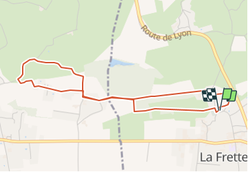
Trail Walking of 5 km to be discovered at Auvergne-Rhône-Alpes, Isère, La Frette. This trail is proposed by raymondfn.
Description
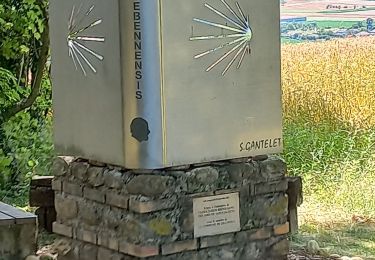
Petite balade depuis l'église de la Frette qui fait le tour du château de la Villardière et nous emmène jusqu'au hameau du Plantier (Saint-Hilaire-de-la-Côte), en empruntant le chemin de Compostelle.
Beaux panoramas sur la Bièvre, Chambaran, Chartreuse et Vercors.
Positioning
Country:
France
Region :
Auvergne-Rhône-Alpes
Department/Province :
Isère
Municipality :
La Frette
Location:
Unknown
Start:(Dec)
Start:(UTM)
684578 ; 5029325 (31T) N.
Comments
Trails nearby
![Trail Walking Bévenais - téléthon Bévenais - Photo](https://media.geolcdn.com/t/375/260/ext.jpg?maxdim=2&url=https%3A%2F%2Fstatic1.geolcdn.com%2Fsiteimages%2Fupload%2Ffiles%2F1553511878bg_sport_marche.png)
![Walking Walking](https://static1.geolcdn.com/sitytour/trail-icons/101.png)
téléthon Bévenais
Walking
Difficult
(1)
Bévenais,
Auvergne-Rhône-Alpes,
Isère,
France
![](/images/other/stat-length.png)
12 km | 17.6 km-effort
4h 9min
![](https://static1.geolcdn.com/siteimages/upload/files/16400158638029165_repeat_loop_refresh_sync_direction_icon.png)
Yes
![Trail Walking Saint-Hilaire-de-la-Côte - RS-Côteau des épées - Photo](https://media.geolcdn.com/t/375/260/ext.jpg?maxdim=2&url=https%3A%2F%2Fstatic1.geolcdn.com%2Fsiteimages%2Fupload%2Ffiles%2F1553511878bg_sport_marche.png)
![Walking Walking](https://static1.geolcdn.com/sitytour/trail-icons/101.png)
RS-Côteau des épées
Walking
Easy
(1)
Saint-Hilaire-de-la-Côte,
Auvergne-Rhône-Alpes,
Isère,
France
![](/images/other/stat-length.png)
4.5 km | 5.1 km-effort
1h 9min
![](https://static1.geolcdn.com/siteimages/upload/files/16400158638029165_repeat_loop_refresh_sync_direction_icon.png)
Yes
![Trail Walking Longechenal - Bellindron - Photo](https://media.geolcdn.com/t/375/260/ext.jpg?maxdim=2&url=https%3A%2F%2Fstatic1.geolcdn.com%2Fsiteimages%2Fupload%2Ffiles%2F1553511878bg_sport_marche.png)
![Walking Walking](https://static1.geolcdn.com/sitytour/trail-icons/101.png)
Bellindron
Walking
Easy
(1)
Longechenal,
Auvergne-Rhône-Alpes,
Isère,
France
![](/images/other/stat-length.png)
10.7 km | 13.9 km-effort
3h 0min
![](https://static1.geolcdn.com/siteimages/upload/files/16400158638029165_repeat_loop_refresh_sync_direction_icon.png)
Yes
![Trail Walking Saint-Hilaire-de-la-Côte - Bocsozel sentier medieval - Photo](https://media.geolcdn.com/t/375/260/91cbdc1b-8001-4f03-93a9-7d4d5430fde2.jpg&format=jpg&maxdim=2)
![Walking Walking](https://static1.geolcdn.com/sitytour/trail-icons/101.png)
Bocsozel sentier medieval
Walking
Medium
Saint-Hilaire-de-la-Côte,
Auvergne-Rhône-Alpes,
Isère,
France
![](/images/other/stat-length.png)
13.1 km | 18.6 km-effort
6h 17min
![](https://static1.geolcdn.com/siteimages/upload/files/16400158638029165_repeat_loop_refresh_sync_direction_icon.png)
Yes
![Trail Walking Bévenais - RD-Le-Grand-Lemps-Bevenais - Photo](https://media.geolcdn.com/t/375/260/ext.jpg?maxdim=2&url=https%3A%2F%2Fstatic1.geolcdn.com%2Fsiteimages%2Fupload%2Ffiles%2F1553511878bg_sport_marche.png)
![Walking Walking](https://static1.geolcdn.com/sitytour/trail-icons/101.png)
RD-Le-Grand-Lemps-Bevenais
Walking
Medium
(1)
Bévenais,
Auvergne-Rhône-Alpes,
Isère,
France
![](/images/other/stat-length.png)
8.6 km | 10.4 km-effort
2h 22min
![](https://static1.geolcdn.com/siteimages/upload/files/16400158638029165_repeat_loop_refresh_sync_direction_icon.png)
Yes
![Trail Walking Saint-Hilaire-de-la-Côte - RS-St-Hillaire-de-la-Côte-Fournache - Photo](https://media.geolcdn.com/t/375/260/ext.jpg?maxdim=2&url=https%3A%2F%2Fstatic1.geolcdn.com%2Fsiteimages%2Fupload%2Ffiles%2F1553511878bg_sport_marche.png)
![Walking Walking](https://static1.geolcdn.com/sitytour/trail-icons/101.png)
RS-St-Hillaire-de-la-Côte-Fournache
Walking
Medium
(1)
Saint-Hilaire-de-la-Côte,
Auvergne-Rhône-Alpes,
Isère,
France
![](/images/other/stat-length.png)
5.2 km | 6.1 km-effort
1h 23min
![](https://static1.geolcdn.com/siteimages/upload/files/16400158638029165_repeat_loop_refresh_sync_direction_icon.png)
Yes
![Trail Walking Longechenal - lonchenal - Photo](https://media.geolcdn.com/t/375/260/f6d5cb5f-e7ca-466b-bee6-ea95851425a2.jpg&format=jpg&maxdim=2)
![Walking Walking](https://static1.geolcdn.com/sitytour/trail-icons/101.png)
lonchenal
Walking
Very easy
Longechenal,
Auvergne-Rhône-Alpes,
Isère,
France
![](/images/other/stat-length.png)
8.1 km | 11.1 km-effort
2h 47min
![](https://static1.geolcdn.com/siteimages/upload/files/16400158638029165_repeat_loop_refresh_sync_direction_icon.png)
No
![Trail Walking La Frette - Le Marais et le Château de La Frette - Photo](https://media.geolcdn.com/t/375/260/ext.jpg?maxdim=2&url=https%3A%2F%2Fstatic1.geolcdn.com%2Fsiteimages%2Fupload%2Ffiles%2F1553511878bg_sport_marche.png)
![Walking Walking](https://static1.geolcdn.com/sitytour/trail-icons/101.png)
Le Marais et le Château de La Frette
Walking
Medium
(1)
La Frette,
Auvergne-Rhône-Alpes,
Isère,
France
![](/images/other/stat-length.png)
8.1 km | 9.6 km-effort
2h 5min
![](https://static1.geolcdn.com/siteimages/upload/files/16400158638029165_repeat_loop_refresh_sync_direction_icon.png)
Yes
![Trail Walking Longechenal - longechenal 2 - Photo](https://media.geolcdn.com/t/375/260/f094b42a-2ba4-4ceb-b6ef-4e22d113281d.jpg&format=jpg&maxdim=2)
![Walking Walking](https://static1.geolcdn.com/sitytour/trail-icons/101.png)
longechenal 2
Walking
Easy
Longechenal,
Auvergne-Rhône-Alpes,
Isère,
France
![](/images/other/stat-length.png)
9.7 km | 12.8 km-effort
2h 25min
![](https://static1.geolcdn.com/siteimages/upload/files/16400158638029165_repeat_loop_refresh_sync_direction_icon.png)
Yes